
The Mercer County Area is now under blizzard Warning!
The term “blizzard” is often tossed around when big winter storms blow in. But the National Weather service has an official definition of a blizzard: A blizzard is a storm with
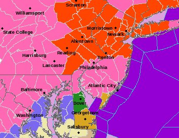
Blizzard Warning Area in Red
“considerable falling or blowing snow” and winds in excess of 35 mph and visibilities of less than 1/4 mile for at least 3 hours. It has nothing to do with of the amount accumulation.
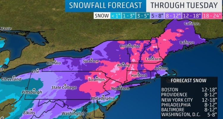
ACCUMULATIONS
In terms of just how much snow we will see seems to vary from every weather report and meteorologist that is reporting it. The consensus seems to be in the 12 to 16-inch range for our area.
TIMING
Snow begins between 10 PM and midnight from southwest to northeast across the warning area, becoming heavy at times with snowfall rates of Three to four inches per hour for several hours Tuesday morning. Snow may mix with sleet for several hours Tuesday morning which could reduce overall amounts. Snow will diminish late in the day Tuesday.
IMPACTS
The heavy snow will make many roads impassable and may produce widespread power outages due to the weight of the snow on tree limbs and power lines. Strong winds will lead to blowing snow, reduced visibility, and additional power outages.
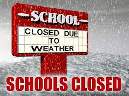
CLOSINGS
State of NJ Offices are closed Tuesday. Essential Employees must still report.
Hamilton Township Schools are closed for Tuesday.
Garbage Collection in Hamilton is canceled for Tuesday
Hamilton Township Municipal Government Offices are closed (library, courts, senior center, etc)


